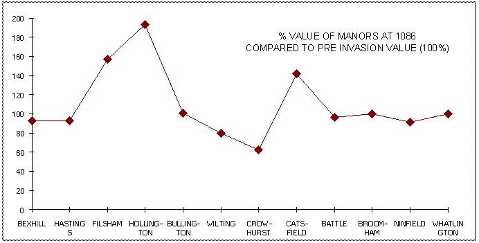
The ‘Domesday Survey’ was conducted in 1085/6 producing accurate data of the values of manors at the Invasion, as well as before and after. This unique database has left historians struggling to make sense of the values, presented to the King, because the wasted manors around William’s camp in Hastings appear to fail to identify exactly where the camp was located. Further, Hastings is left out of the survey without a reason being given. We shall examine this document in detail and come to conclusions that identify both the manor where the Normans camped and also where they fought. Only one manor fulfills these obligations since it was the most wasted of all the manors and sits in plain sight in the survey. This simple analysis just uses the data from ‘Domesday’ effectively naming the manor where the Normans camped and the manor in which they fought. This can be deduced by looking at the values of the two most wasted manors. The most wasted being where the armies fought and the second most wasted where William camped on the eve of the landing, spending three weeks in the same camp.
The manors around Pevensey and Hastings fall into four distinct categories. These are:
1) Those manors who’s value before, during and after the Invasion remained the same. It is concluded from this that the Normans are very unlikely to have visited, let alone camped in those manors. In consequence these manors were eliminated from the search.
2) Those manors with a very low value less than 5shillings. These were also eliminated from the search upon the basis that any increase or decrease in value by a very small amount could distort any reliable percentage fluctuations.
3) Those whose value decreased at the time of the Invasion and subsequently increased, recovering some or all of the lost value in the 20year period. The values for the core data for the study, since the reduction in value shown at the time of the Invasion is assumed to be caused by the presence of the Norman army sustaining itself.
4) Those manors reported to have been laid waste at the time of the Invasion. These form the most likely source for the Invasion landing and Norman camp site.
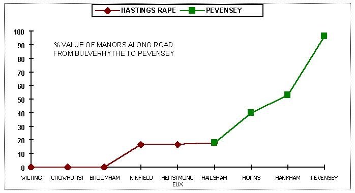
In order to evaluate the information supplied in the Domesday Survey it is necessary to look at the geographical spread of the manors in the Hastings and Pevensey Rapes at the time of Domesday (see Secrets of the Norman Invasion One.

All the manors are marked according to their geographical position. This is then expanded to eliminate all those manors which do not satisfy the stated criteria leaving 81 values, some of which include secondary values as follows.
Taking this plan each of the manors is examined to see what the value was at the time of the Invasion showing the geogrphical spread of the study manors. This value is then marked according to the band of values expressed as a percentage of the pre-invasion value. These are marked according to six value bands by colour where:
1) WASTED - Where there is no value - Red
2) Where the value is up to 35% of the pre-invasion value - Pink
3) Where the value is 36 to 50% of the previous value - Yellow
4) Where the value is between 51% and 65% - Pale Yellow
5) There the value is 66% to %80 - Pale Green
6) Where the value is 81% to 100% - Dark Green (virtually no wasting).
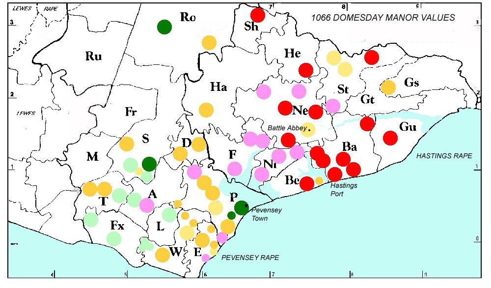
The manors are then displayed upon the basis of the London Road from Hastings to Pevensey. Two things are immediately apparent from the visual display. Almost all of the Pevensey Rape Manors are on the right hand side (green) and those on the left side Hastings Rape (diamond markers - in red). Secondly the graph shows values in a straight line distance from Wilting. It therefore shows values in relation to the distance from Wilting. This colour version below identifies as clearly as possible why the Battle of Hastings did not take place in Battle, identifying the ridge beyond which it was not possible to travel with a horse and cart north from Crowhurst on the London Road. This element has been unknown to historians as the factor that stopped the Norman army from plundering Battle. It may have added value to the town and could be the unstated reason the Abbey was built there.
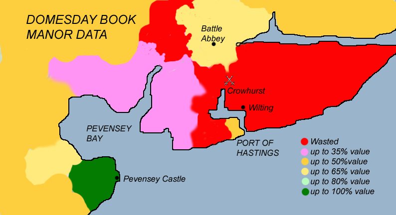

This shows in a simple visual format that the further away from the Wilting site the less the devastation of the manors took place. Wilting, Crowhurst and Broomham suffered the greatest devastation of all manors (full details in published work, but the reason for this was unknown in the past. The route chosen was the proposed route from Wilting to Pevensey using the surviving route around Pevensey Marsh. It became the coastal route prior to the development of the A259 in the Middle Ages.
The manors where therefore arranged in order of the distance along that route and produced a clear indication that the Domesday Manor values were related by distance between the two sites Pevensey and Wilting in the following graph:
Whese are all wasted manors and when the values are compared to the pre-invasion value, in order to evaluate the percentage drop in value created by the Normans, we can see the most wasted of all the manors is at the bottom of the dip in the next graph.
Wilting comes out the second most wasted manor indicating a key unknown involvement in the Invasion. Dr. Marjorie Chibnall, from Clare College Cambridge wrote in 2010 that the work ‘provides enough evidence to indicate Wilting was probably the base camp of William the Conqueror.’
Now with other data we can see why Domesday throws up these otherwise inexplicable anomalies and why no-one else since records began has a logical explaination of the values. We know that Wilting was the most wasted manor, because it was the camp site of William the Conqueror and therefore took the greatest raveging from the Norman army. Crowhurst on the other hand was owned by Harold and whilst it had a greater population than Wilting at the start it can only have been totally destroyed by the battle of Hastings, which took place at the time of the Norman Invasion.
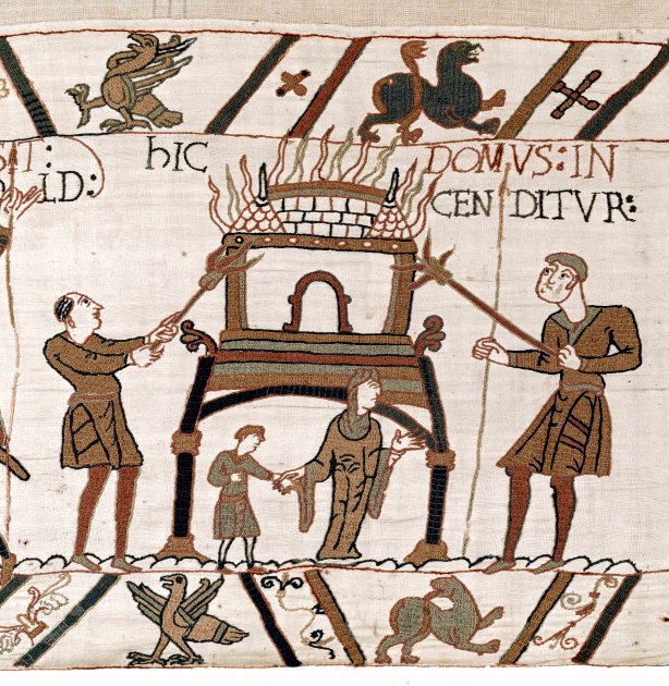
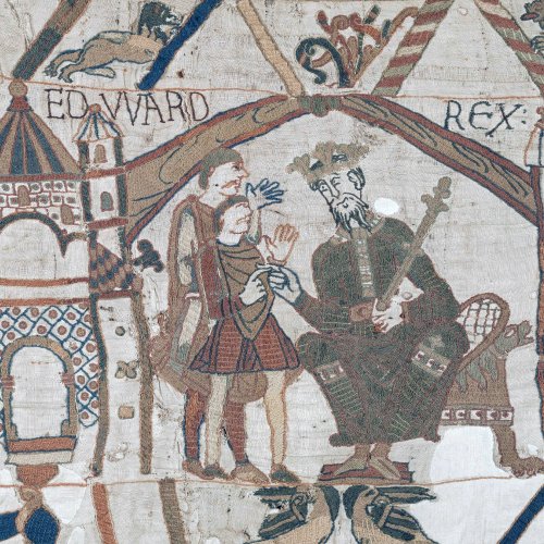
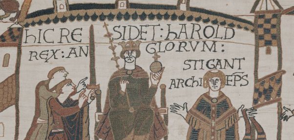
A point is raised in the Domesday Survey Report (on page 37) published in 2011 that you might expect to see values immediately adjacent to Pevensey reduced dramatically, if Jumieges, Poitiers and the Bayeux Tapestry are interpreted to mean that the Normans landed there. It has taken ten years to provide an indisputable rebuttle to this false claim. It is understood that the problem lies not with the documents of the time, but the people who seek to interpret and translate them. It has now been established beyond any reasonable doubt that the scientific analysis of Domesday cannot be tweaked to your particular liking. It is real undeniable data that shows the Normans did not land or camp anywhere near Pevensey, providing authenticity for all the other documents listed on this site, where each confirms data in others from the same list. For the benefit of doubt they all agree and are:
CHRONICLE OF BATTLE ABBEY
DOMESDAY BOOK
QUEDAM EXCEPIONES
WACE
WILLIAM DE JUMIEGES
WILLIAM DE POITIERS
ORDERIC VITALIS
GESTA NORMANNORUM
THE CARMEN
HENRY OF HUNTINGDON
WORCESTER CHRONICLE
ANGLO-SAXON CHRONICLE
BAYEUX TAPESTRY

Image taken from the Bayeux Tapestry featuring the Saxons lined up to fight with their axes and shields at the Battle of Hastings
We come to the conclusion that Domesday indicates that the Normans could not have landed at Pevensey and the Normans did not fight at Battle Abbey. This has left the public gasping for air unable to understand why the Bayeux Tapestry, the most respected Norman source document, shows the fleet mid channel with the slogan ‘Ad Pevensey’ engraved upon it. Surely these other texts such as Domesday and the Chronicle of Battle Abbey must be wrong? That is what the historians who wrote about it thought. A terrible mistake that we shall correct in the following document called the ‘Quedam Exceptiones de Historia Normannorum’.

